Research Projects
|
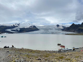
South Iceland (2022-Present) My current postdoc work investigates future proglacial lake evolution and outburst flood hazard in Iceland, focusing on outlet glaciers on the south coast. Iceland's glaciers are rapidly retreating, expanding meltwater lakes and destabilizing surrounding slopes. How will glacial lakes develop under future climate warming scenarios, and how will this affect flood risk from mass movement events into lakes? If a flood does occur, how will it impact landscapes and infrastructure downstream? Southwest Iceland (2016-Present)
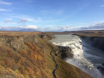
My dissertation research investigated a series of glacial lake outburst floods (known in Icelandic as jökulhlaups) that drained during Icelandic Ice Sheet deglaciation in the Late Pleistocene-Early Holocene. These catastrophic events left extensive Earth surface evidence along the Hvítá River, including Gullfoss--Iceland's most famous waterfall. I used a range of methods to reconstruct flood timing and dynamics, including geomorphologic mapping, cosmogenic nuclide exposure dating, tephrochronology, and hydraulic modeling. Results advance our understanding of Icelandic paleoenvironmental change, ice sheet response to climatic warming, and the role of extreme events on landscape evolution. These floods may also serve as an analogue to contemporary jökulhlaups from ice-dammed lakes, which pose a significant geohazard in Arctic and alpine regions worldwide due to climate-driven glacial lake expansion. Northeast Iceland (2014-2016)
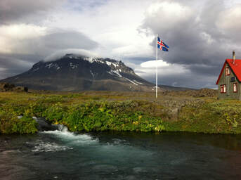
My Master's thesis investigated geomorphology and chronology of Holocene jökulhlaups along the Jökulsá á Fjöllum River, the site of the largest known floods in Iceland. Field work focused around Mt. Herðubreið and included geomorphologic field surveys and sample collection for cosmogenic nuclide exposure dating. Imja Lake, Nepal Himalayas (2016)
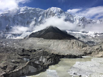
I assisted a research team from the UT-Austin Department of Civil, Architectural, and Environmental Engineering in a project studying glacier change, glacial lake development, and glacial lake outburst flood (GLOF) risk at Imja Lake, perched at an elevation of 5000 meters in the Khumbu region of the Nepal Himalayas. Field work involved geomorphologic mapping, measuring glacier debris cover thickness using GPR (Ground Penetrating Radar), kayaking Imja Lake to survey bathymetry using sonar, and installing a weather station on the glacier to record year-round environmental conditions. |
